DAWN RICHARDS

November 14, 2016 -- Hiking from Rim to River -- Grand Canyon National Park
As a avid hiker and photographer in Arizona, I've hiked many trails within the Grand Canyon and have many favorite spots we like to visit. Hiking from Rim to River is considered one of the "World's Ten Most Dangerous Hikes" for good reason. It is mainly due to the extreme heat. While summer visitors at the rim may be enjoying temperatures in the 80's (7,000' elevation), the ground temperatures on trails at the base of the canyon can be 130 degrees (110 in the shade). Obviously, to do this iconic hike, being prepared for the conditions is the most important aspect. We decided to backpack with our gear to the river and back, and expected inspiring views along the route. We also anticipated a bit of a challenge since both of us had firmly stepped into our middle age years.
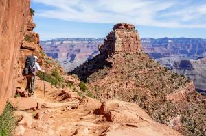
We decided to hike down the South Kaibab Trail on the South Rim. The South Kaibab trail has a steep descent and offers no protection from the elements along 6.3 miles with no fresh water access. Why? Because it offers beautiful 360 degree panoramic views (and it's just a little shorter)! The first panoramic opening on the trail is rightly named Ooh Ah Point as it offers a fantastic view. After many switchbacks, we arrived at Cedar Ridge which seemed to be a popular turnaround point for a lot of day hikers and hungry squirrels. Next up, was Skeleton Point which offers a very scenic 360 degree view and then the trail changes in elevation dramatically. As we descended the switchbacks here, we had our first glimpses of the Colorado River. We hiked past Tonto Platform and Tipoff, and through the steepest grade at an average of 22%. The heat has also intensified as we arrived at the tunnel just before the black bridge across the Colorado River which is shared by the mule teams. We then hiked along the river in deep, hot sand for another mile until we arrived at the Bright Angel Campground for the night. (Total 7 miles, Elevation change 4,860 feet)
Leaving from the bottom of the canyon, we hiked along the river and cross the silver bridge over the Colorado River toward the River Resthouse through thick sand dunes. We then started our ascent on the Bright Angel Trail which almost immediately begins with an area known as the Devil's Corkscrew. Once we made it through that area, the climb continues through more rock carved areas with a gentle creek alongside the trail. The creek gave rescue to the heat as we soaked our bandanas and hats to cool off with many other hikers. We arrived at Indian Garden Campground where we decided to stay for the afternoon (5 miles). It was worth it to be able to hike out to watch the sunset from Plateau Point and enjoy another night in this beautiful canyon. The next day we were on the trail again before sunrise and started our trek up the rest of Bright Angel Trail through the switchbacks to the top of the rim passing 3 Mile Rest, 1.5 Mile Rest and both tunnels. (Total 9.5 miles, Elevation change 4,460 feet)
We like reminiscing about the fun we had on our journey, and are planning to spend a little more time at the bottom next time. The best parts were the awe-inspiring scenery coupled with quality time with my favorite person.